


Mitigating Whatcom Flooding
(Created in ChatGPT)
Mitigating Whatcom Flooding
Mitigating Whatcom Flooding
Whatcom County’s Lower Nooksack River faces a systemic flood risk problem that has developed over decades due to river alterations and changing climate conditions. Flooding in this area has become increasingly frequent and severe, causing significant damage to homes, farms, roads, utilities, tribal lands, and ecosystems. Following is a summary of the problem, its causes, impacts, some proposed solutions, and funding strategies.
The Problem
Flooding in the Lower Nooksack River watershed has become repetitive, regularly overwhelming levees, drainage systems, and emergency response capacity. The problem stems from decades of river modifications and worsening climate conditions, as well as sea-level rise.
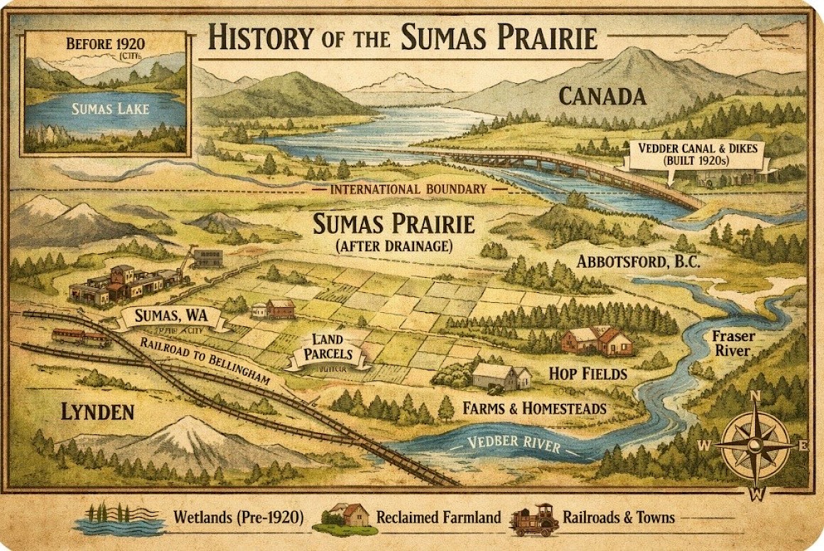
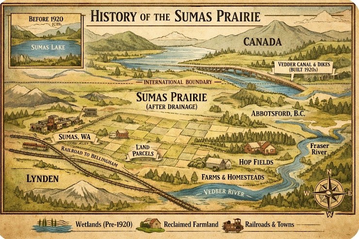
The flooding affects five key areas of the Lower Nooksack River: the Nooksack delta and tidal backwater near Bellingham Bay, Lynden and its agricultural flood plain, Ferndale and downstream agricultural land, and the Everson area. All of this is caused by heavy sediment buildup upstream that then feeds a system which flows into farms, neighborhoods, roads, dikes, drainage districts, and tribal fishing areas.
This flooding has evolved over decades but has accelerated since the 1990s, due to repetitive high-water events, increased winter rainfall, loss of snowpack, and sea-level rise. We see the damage on a regular basis:
-Destruction of structures
-Crop loss and soil contamination
-Road closures and emergency access issues
-Levee failures and drainage system breakdowns
-Loss of salmon habitat and tribal fishing access
-Increased insurance costs and declining property values
Adding significantly to the issue, is that climate change is expected to exacerbate flood frequency and depth, which will further increase public liability and future damages. These costs are projected to range from $1.8–3.9 billion over 30 years, if no action is taken.
While there are many causes for flooding, unfortunately, we in Whatcom County are at a stage where climate change and human meddling are converging into a perfect storm. The solutions will be expensive and inconvenient. Doing nothing will be even more costly and destructive
Causes
The problems began when our historic wetlands and side channels were filled-in or cut off, leaving floodwater with nowhere to go, which increased flood levels. Upstream, sediment began raising riverbeds, which reduced channel capacity and caused flooding at lower flows. So we built levees which prevented floodwater from spreading naturally; causing higher water levels and faster flows, as well as a need for constant repair and failure.
On the climate side, increased winter rain, reduced snow storage, and rain-on-snow melting events lead to longer flood seasons and higher peak flows. Sea-level rise worsens this effect when high tides slow river drainage, causing floodwaters to backup into upstream areas.
These issues, small things at first, are now snowballing into real problems as our floodgates and drainage infrastructure age while we continue to develop in historical floodplain areas. Repetitive FEMA disaster declarations bring rising public costs and insurance losses as well as increased legal exposure for our agencies. As community confidence in flood protection declines, so do our salmon populations. And as our governmental funding systems fragment, we continue to rely on emergency-based flood response instead of long-term planning.
Solutions
Unfortunately, no single fix can solve the problem. We need to look at the big picture and address root causes rather than symptoms.
-Moving levees back from the river will allowing floodwater to spread out; reducing flood heights and velocities.
-Initiating a voluntary buyout program will remove vulnerable structures and eliminate the costs of repetitive losses.
-Removing sediment from constricted areas will restore channel capacity without endless dredging.
-Recreating natural flood storage will improve salmon habitat and reduce downstream flood peaks.
-Restoring tidal wetlands will improve drainage during high tides, buffer sea-level rise, and reduce backwater flooding.
-And finally, modernizing our failing infrastructure will improve interior drainage and reduce farmland flooding.
Costs & Conclusions
The total cost of implementing these solutions ranges from $500–$850 million over 30 years, with a low estimate of $300 million and a upper-end estimate of $985 million. A benefit-cost analysis shows these solutions will avoid $1.85–$3.9 billion in future damages. At a cost of $500–$850 million, this results in a benefit-cost ratio of 3:1 to 4.6:1. That ratio exceeds all federal funding thresholds. (To see a breakdown of estimated costs and funding sources, see Phased Implementation and Funding document in RELATED FILES below.)
The Lower Nooksack flooding problem is well-documented and is solvable. Continued reliance on emergency repairs and levee maintenance will only increase costs and risks. A phased, watershed-scale investment in floodplain reconnection, targeted infrastructure improvements, and voluntary buyouts offers the lowest long-term cost, the greatest risk reduction, and the strongest ecological benefits.
The knee-jerk response, of course, is that we cannot possibly afford to do it. The real question is, how much longer can we afford not to do it?

11 Comments