


City-Created Floodplain Threatens 62 Homes


City-Created Floodplain Threatens 62 Homes
City-Created Floodplain Threatens 62 Homes
The Problem
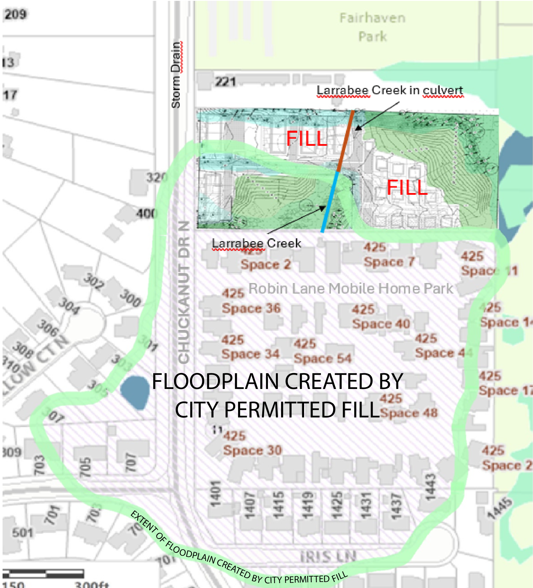
In 1991, the city issued a “fill permit” at 331 Chuckanut Dr N., a parcel between the red apartment/cabins abutting the southern edge of Fairhaven Park and the mobile home park retirement community on Robin Lane. The Chuckanut storm drain project commenced the following year, sparking speculation that the fill was a convenient cost saving measure for disposal of the excavation spoils.
The planning department decided the historic creek, which drained this watershed was not a creek. That decision would not have been legal after the Critical Area Ordinance was passed. The “not-a-creek” was placed in a 3' culvert, and 14 to 25 feet of fill was placed over the culvert, damming the watershed. This watershed extends from Padden Creek to Viewcrest, and from east Edgemoor to the 100 Acre Wood. Currently, there are two drains for this area: the 3' creek culvert and the 4' storm drain in Chuckanut Drive.
But, as you can see on the map, the city’s fill created a new floodplain which now includes Robin Lane and Iris Lane - and a total of 62 homes.
Today, the Bellingham Planning Department is facilitating a 33-unit development on the site. The plan includes blocking the 3' culvert and diverting the creek into the Chuckanut Drive storm drain. A 4-unit townhouse (building 5) is planned on top of the fill, directly over the existing drainage, eliminating one of the drainage paths for the floodplain. While the City asserts adequate capacity in the storm drain, during extreme storm events this revision could allow water to flow from that storm drain into the “Robin Lane basin” that the city created.
Before the era of historical developers C.X. Larabee and J.J. Donovan, the watershed drained through the lowest elevation, like it still does through the culvert. If the development plan is approved as-is, and the Chuckanut storm drain is overwhelmed or fails, water will find the lowest elevation over the fill. That would make everything that is upstream, and lower than the fill, into a lake that would flood the 62 homes of Robin Lane Mobile Home Park and the northern half of Iris Lane.
Bellingham City Planner Ryan Nelson cites engineering studies using projections for a 500-year flood. They conclude there is enough capacity in the Chuckanut Drive storm drain to drain the entire watershed. He also assures us that the Public Works Department will maintain or enlarge the Chuckanut storm drain if necessary, according to the Western Washington Stormwater Management Manual. But will the Chuckanut storm drain withstand the major earthquake forecast for our region? The Planning Department is betting 62 homes against the failure of the Chuckanut Drive storm drain.
The City of Bellingham updated their flood map in 2017, clearly showing the floodplain that includes Robin Lane Mobile Home Park and the northern half of Iris lane. That update is an acknowledgement that the city-permitted-fill has created the floodplain. Even if the proposed drainage works, these properties are now burdened with a floodplain classification and may lose value due to that classification. If the drainage fails, will the city be liable? Will they indemnify the residents? Are they vulnerable to being sued for a taking of value?
The Solution
Eliminating the floodplain basin by daylighting Larrabee Creek would remove the flood risk to current residents of Robin Lane and Iris Lane. The natural creek could be a positive feature not only aesthetically for current and future residents, but it would be environmentally beneficial as well and it would eliminate the flood danger to Robin and Iris Lanes.
Please ask the city to daylight this historic creek. Reference the development proposal at 331 Chuckanut Dr N.

5 Comments